
As far as is known, the Jewish presence in San Vito dates back to around the middle of the 16th century. The Jews arrive there, as had happened in Portogruaro, probably coming from Venice, thanks to the favor granted them by the patriarch of Aquileia, lord of the place, and by the municipal authority.
Initially, they correspond to one or two families who support themselves by carrying out craft activities and lending money. This second activity assisted the credit needs of the inhabitants of San Vito, who otherwise had to resort to loans subjecting elsewhere to unregulated and particularly onerous usury rates.
At the time, the Jewish communities present in the territory for the burial of the deceased referred to the cemetery located on the Venice Lido. It was during the following century that the Jews of Portogruaro acquired a cemetery area located in the township where the thirteenth-century church of San Francesco was located, previously called Borgo San Gottardo. It is here that the Jewish inhabitants of San Vito also bury their dead. But the size of the area available does not allow unlimited use over time.
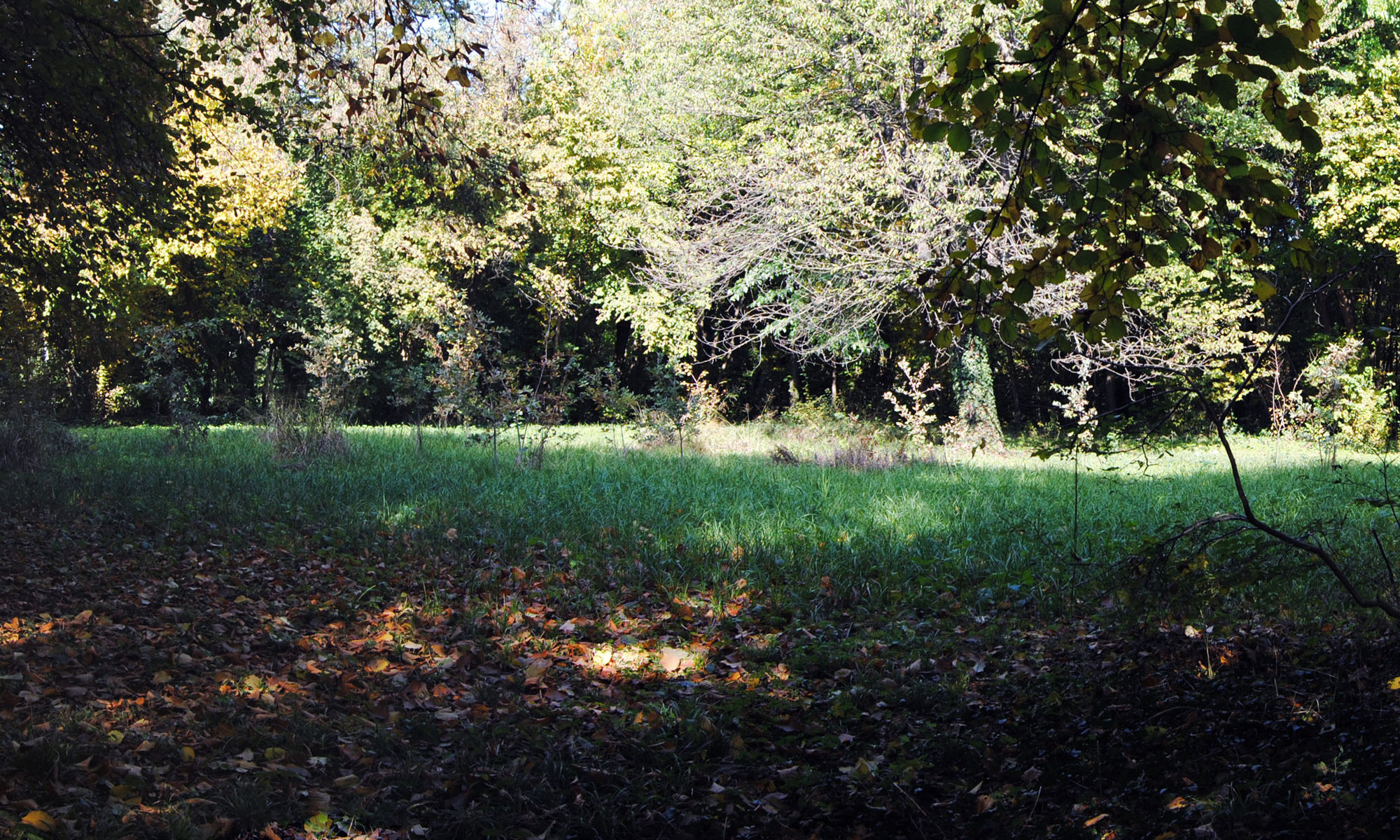
Thus, in 1687, a certain Leon Romanin, a doctor, applied to the Council of the Magnificent Community of San Vito to obtain the concession of a place in which to bury the deceased located in the appurtenances of the Bosco della Man di Ferro, a forest owned by the municipality and previously for collective use, of which he was a tenant. Trusting in the benevolence of the authorities of San Vito, he addresses a plea to them: he appeals to the “pietas” of “Catholic Christian people” who professed “to exercise piety and charity”.
The place, distant from the town of San Vito, was located in the territorial area denominated in the topography of the 19th century with the toponym Boscato, which qualified its natural state as an area in which there were vast areas of wood, interspersed with others put under cultivation after the alienation, which took place in the previous historical moment by imposition of the Venetian government, of part of the municipal properties. In this sector of the territory some cadastral subdivisions of the public property together made up the so-called “Bosco di San Vito”, a forest area that extended from the north-eastern end, represented by the Bosco della Man di Ferro, in the direction of the current surviving wooded flap located north of locality Le Torrate.
The site was reached along a stretch of the ancient historic road, the original Strada Regia, later called “Fossera”, but which at the time was indicated with the generic name of “Vial”. It connected the town of San Vito with Taiedo, which was once the epicenter of the feudal interests of a family branch of the Altan and from where it was possible to continue, crossing the road coming from Le Torrate, alias Castel di Sbroiavacca, to Frattina and in the direction of Treviso. This route, which still exists and can be easily followed on a dirt road from the locality Torricella at least as far as the Boscato farmhouse, after the bridge over the water known as “Il Prodolon” undergoes a fork that branches off in the direction of the cemetery.The detour is indicated in the previous historical maps it too as “Vial” or otherwise in the Napoleonic land register as “road known as Cocuba”.

However, we probably had to wait until 1765, when the site was purchased in the name of the “Community of the Jews” of San Vito by Shemuel Romanin, so that they could fully enjoy the right to bury their dead in the chosen place. It is in this period that the small Jewish community can count on the local presence of six families before their disintegration and of the social nucleus for the migration elsewhere of their components after the end of the Republic of Venice sanctioned by the treaty of Campoformio.
The only lapidary testimony present in the area dates back to 1798, probably transferred from here and walled upside down on the external side of the perimeter wall of a rural building located in Savorgnano.
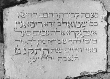
This translated epigraphic monument reads:
“Tombstone of the buried, the wise physician / Shemuel ben Iudah Romanin / who was called to the heavens above / on the sixth day of the month marheswan to shine / like a living light, in the year 5559. / Let his soul be bound in the bundle of the living. He left us and all Israel alive.”
The late Shemuel Romanin, in his lifetime, obtained his doctorate in Padua, practiced the profession of doctor, the only doctoral professional outlet that was granted to Jews, earning merits towards the community. In 1758 he was granted a license to practice surgery by the Provveditori alla Sanità of Venice, at that time a separate competence from the medical profession, a profession which at the time had its roots in a disciplinary corpus that relied on embryonic scientific notions filtered through a consolidated cultural tradition of an anthropological-humanistic matrix.

It was in those years that Leon son of Shemuel will cede the family assets to the Congregation of San Filippo Neri of Venice, but evidently with the exclusion of the cemetery area if in the Napoleonic cadastre it still appears in 1810 as the property of Leon Romanin and his brothers, sons of the late Shemuel.
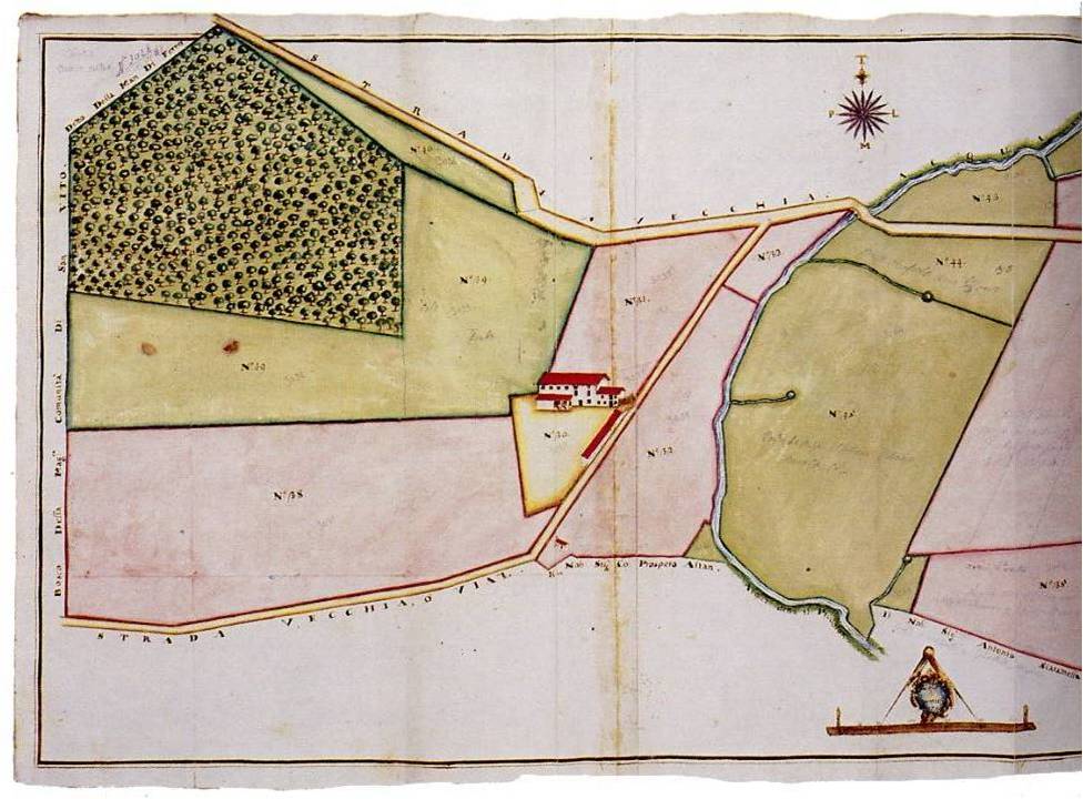
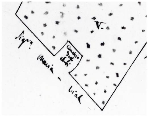
A map of municipal assets, datable to around 1826-27, shows in the parcelling out of the Bosco della Man di Ferro the parcel indicated as the Jewish Cemetery as still present. These assets, acquired in 1851 by Vittorio Vial, will then flow by inheritance into the agricultural heritage of Lucia Falcon Vial, from whose testamentary bequest the welfare work will take shape which will later become the Falcon Vial Agricultural Institute.

The establishment of the public interest patrimonial body is a chronicle of our times, today merged into the homonymous Falcon Vial-Fabrici-Morassutti Foundation, whose administration, at the origin of recent events, in 1985 implemented the decision to put up for sale the landed property pertaining to the eighteenth-century farmhouse that belonged to the Filippini Fathers, including the small area of worship.
The acquisition by the province of Pordenone of the parcels of land that made up the naturalistic-environmental redevelopment area established for the interest of a committee of citizens created ad hoc in that circumstance and which today has become the Volunteer Organization called Bosco della Man di Ferro, realizes a protection of the place that is still active despite the recent events related to the transfer of public ownership.
Gianfranco Bertani